Before we left Lazy Bend Campground near Estacada, OR, we drove our tow car to Olallie Lake, a scenic area east of Portland in Mt. Hood National Forest -- and where Season and Lee want us to spend a long weekend with them and their boys. The lake is beautiful, but the last two miles of the trip are on an unimproved gravel road ... and we’re thinking it’s too bumpy for all the systems in our motor home. So we may have to go to plan B with them.
However, it was great to see the area. In 1995, Jim started a five-day, 50-mile segment of the Pacific Crest Trail from nearby Breiten Bush Lake, just four miles from Olallie Lake.
Tuesday we drove north to Washington’s Seaquest State Park, 50 miles west of Mt. St. Helens. The campground is full of Douglas Fir trees so big Jim and I together would not be able to stretch our arms around them. A side note: It took us over an hour to level our rig at our campsite. Luckily for us, we got to the park early in the day and did not have an audience; it’s embarrassing to drive the rig up on the levels, then drive them off, reposition the rig and the levelers, repeat, repeat, repeat while Jim and I are trying to be civil to each other -- and while neighbors roast hot dogs and watch. Or worse, stroll over and start advising.
Wednesday (July 4th) started with a stop at the Mt. St. Helens Visitor’s Center just across the street from our campground. There are four visitor centers on State Route 504 (also called the Spirit Lake Highway), which is the approach to the west side of Mt. St. Helens. We hit all of them. I think I finally have a basic understanding of what happened on May 18, 1980: (besides the basic fact that Mt. St. Helens, the youngest and most active volcano in the Cascade mountains essentially blew up): An earthquake caused the north face of Mt. St. Helens to collapse, which caused a massive landslide. Then the volcano erupted, sending smoke, steam and debris ten miles into the air. The combination of power, fire, melted ice and snow, rock, soil and dirt created a massive force that leveled trees as far away as 17 miles from the mountain and sent a debris slide down nearby streams as far away as Interstate 5 -- 52 miles away.
 |
| Olallie Lake and Oregon’s Mt. Jefferson, one of the most difficult to reach volcanoes in the rugged Cascade Range. The segment of the Pacific Crest Trail Jim hiked followed the base of the west side of the mountain. He took his black lab/Irish setter mix Steve with him. They hiked it in August but there was still snow on parts of the trail; they also sat out a thunder storm Jim thought might blow the tent away. |
 |
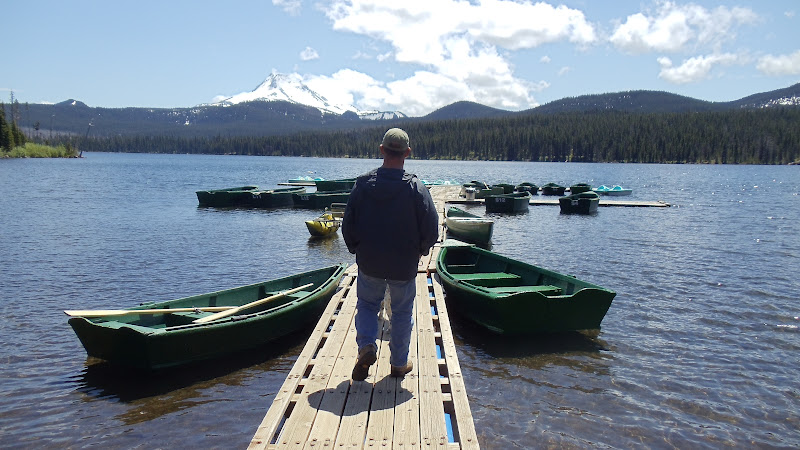
| Jim and Cooper on an Olallie Lake Pier, with Mt. Jefferson in the background. |
 |
| Our campsite at Seaquest State Park in Washington. We’re about 50 mils due west of Mt. St. Helens between the tiny towns of Silver Lake, WA and Toutle, WA. |
 |
| I have never seen foxglove growing in the wild, but they are all over the roadsides to Olallie Lake and on the way to Mt. St Helens. Jim said they were all over the forests he worked in as an Oregon forest ranger. |
 |
| Here’s Jim among the Douglas firs at Seaquest State Park. |
 |
Bev with a downed Douglas fir.
 |
Mt. St. Helens as seen from the visitors center at
Silver Lake, WA and right across the road from our
campground. The explosion occurred May 18, 1980,
just six weeks after my daughter, Ashley, was born. |
 |
Bev with Mt. St. Helens in the background from a closer
vantage point. The white plume visible in the center of the
crater in mountain is steam, as Mt. St. Helens is still active.
When the volcano erupted in 1980, it sent ash to 11 states.
One of the worst cities hit by ash was eastern Washington’s
Yakima, where Jim’s parents lived. Jim said his mom told
him that when the sky went dark she thought it was a
rainstorm -- until she went outside and felt ash. Portland
was more lightly covered by ash in an eruption one week
later.
 |
Bev near one of the douglas fir trees that was snapped like a
matchstick by the force of explosion. Trees further from
the blast remained standing but were stripped of limbs
and bark. On the federal land closer to the mountain,
trees were not replanted. Instead the area was left as is
so scientists can study how nature reacts after a volcano.
 |
A great interpretive display at the Johnston Ridge Observatory
at the base of Mt. St. Helens explained the effects of the
eruption with narration and a series of different colored
lights. The observatory is named after David Johnston,
a volcanologist with the United States Geological Survey
who died in the eruption. A total of 57 people died -
probably the most famous was Harry Truman, owner
of a lodge at the base of the mountain who refused to
leave. Most of the others who died were not in the
restricted area around the mountain and obviously
no one expected the aftermath to be so fierce.
 |
The Toutle River valley was devastated by the blast and
still has a way to go before it's covered with large trees.
Mt. St Helens had previously exploded in the mid 1800s.
Since then the only other volcano erupted on the
continental US occurred at Mt. Lassen in northern
California in 1915.
|
|
|
|
|


No comments:
Post a Comment