Friday, August 29, 2014

Troy, Montana, and the Kootenai River

We’re at a campground 2 miles west of Troy, Montana.

Troy is a town of about 1,000 people, has the lowest elevation of any town in Montana, and is just 12 miles from the Idaho border  Our campground is on the Kootenai River which both starts and ends in Canada. Crazy. Where the river flows in Canada it’s called the Kootenay River; when it’s in the US, its name is the Kootenai. Like many things in the western US, the river is named for a Native American tribe.

Today was a laid-back cleaning day.  We cleaned the rig inside and out (except for the top front which is hard to reach. I’m hoping we can get to that soon because it’s very buggy). We did the laundry and Jim cleaned out the car. Nothing against Cooper, but the Honda had big-time eau de canine going on.

And we explored Troy. There's lots of hiking nearby but we're going to miss it this time.
A private road from the campground takes you to the Kootenai River.  I was walking it by myself and wondering if I should have brought my bear spray when I heard a noise.  Luckily it was a white tail deer.
This is the US-2 bridge over the Kootenai. It's not far from our campground and was built in 1948, said our campground host.
This is the old bridge over the Kootenai. Until the (new) bridge was built in 1948, this was the Kootenai River crossing for US-2. The bridge looks like it was built for horse-pulled wagons and Model Ts, and probably was, but that's Jim in our Honda. 
The Kootenai River and Troy, Montana, as seen from old US 2. Jim's grandmother and two uncles lived in Troy according to the 1940 census.

Wednesday, August 27, 2014

Glacier National Park: Kayaked one lake; hiked to another

Yesterday we kayaked on Lake McDonald, Glacier National Park's largest lake and thought to be named for explorer Duncan McDonald who carved his name in a nearby tree in the late 1800s. The Native American name was "Sacred Dancing," which might refer to ceremonies held near the lake. It's a beautiful, clear lake.

Today we took the park's free shuttle about 15 miles up Going to the Sun Road to the trail head for Avalanche Lake. The hike to the lake is the park's most popular hike, so we saw plenty of people. But we also had long spaces where it seemed like we were all by our selves. The trail took us through a 400-600 year-old forest with a moss-covered floor, past a creek and all the way to a turquoise lake.  
Bev's kayak near the edge of McDonald Lake.  The lake is clear, which means not much stuff is growing in it.  And because not much stuff is growing, it's not much of a fishing lake, although it is home to some trout, whitefish, kokanee salmon, and suckers. We didn't see anyone fishing on the lake.
Jim on Lake McDonald. There is no marina with gasoline on the lake, so there are not a lot of power boats -- which is OK by us.
Lake McDonald, mountains and Jim again. The lake is ten miles long and as deep as 500 feet.
Glacier's sister park is Waterton Lakes National Park, just across the US border in Canada.  Together the two parks are the Waterton-Glacier International Peace Park.  Here's Bev and a Mountie at the Waterton information center in Glacier.
Last night we took Cooper for a walk along Lake McDonald. Cooper may be 15, but he's still a handsome dog. However, he's never been especially happy that someone other than Jim joined the pack.
A nice hiker near the beginning of the trail offered to take this pic.
Also near the beginning of the hike were trees that look like they snapped during a micro burst.  We're thinking it might have happened during a quick moving storm we experienced when we were at Glacier last August. That storm also toppled trees near (but fortunately not on) our campsite.
Bev did not edit this photo -- Avalanche Lake really looks this color of blue.
Jim at Avalanche Lake.
I just happened to catch a butterfly on these asters. Flowers are in bloom all over Glacier.  
This mule deer walked right by us on the Avalanche Lake trail.
And thank goodness for a telephoto lens when we caught a glimpse of this guy on the trail.  In reality, we saw him stuffed at the Waterton Lakes Info Center. If we'd really seen him on the trail, it would have been in the post title and Bev would still be recovering. 

Tuesday, August 26, 2014

Red Bus Tour at Glacier National Park

Yesterday was Red Bus day for us when we took a tour of the same name at Glacier. Our tour was 32 miles on Going to the Sun Road from Apgar Visitors Center to the Logan Pass Visitor Center near the Continental Divide.

The Red Bus fleet consists of thirty three 17-seat (18 counting the driver) motor cars. The buses and their drivers started taking visitors on tours via Going to the Sun Road -- the only road that completely bisects the park -- since that road opened in 1933.

The buses have both gasoline and propane engines and feature canvas roofs that roll back, giving riders a clear view. They were built in the 1930s and refurbished in the early 2000's.

Grand finale of the tour:  We finally saw a bear. This guy was a small black bear (actually brown in color) sitting along the side of the road, happily stripping leaves off a shrub. We also saw a mountain goat. Jim said the tour was a heck of a lot better than driving (the road has steep drop offs on one side, rock overhangs on the other and plenty of twisty curves) plus you get great stories all along the way.
The new Apgar Visitor Center opened this spring. We got on the tour bus at the far end of this building.
Our Red Bus as seen from the inside before the roll back canvas roof came off.  That's tour guide Norm at the left starting to raise the roof, so to speak.
With the top off, Norm gives us a few instructions before we leave (the two main ones were "don't stand up while I'm driving" and "I'll shut the doors myself, thank you very much."  Norm was a great tour guide.  When he's not working at Glacier, where he's spent 8 summers, he lives in Columbus, Ohio.  So he noticed the Ohio State hoodie Bev was wearing.
Our tour bus group, as seen in the bus's rear view mirror.  You can see me to the left taking the photo, and Jim to my left.  You know it's cold when Jim has a windbreaker and a hoodie pulled up over his baseball cap.
Several times Norm pulled the bus over and we could stand up and look out the top of the bus.  We also made three stops where we got out of the bus; one of those stops was the Logan Pass Visitor Center near the Continental Divide.  That's also where our tour headed back.  If we'd kept going, the road would take us another 18 miles to St. Mary's Visitor Center on the east side of Glacier.
Jim on tour stop.
Tour guide Norm is the one with the tie. Per Norm, Glacier has 23 active Glaciers but because our climate is getting warmer it's anticipated they will all disappear within ten years.
Norm said it had been foggy the last ten days, but it was beautiful if a little chilly. 
More pretty scenery on the tour. Vehicles longer than 21 feet are not allowed on Going the Sun Road.  However, tour guide Norm told a story of seeing a big Class A being driven by a guy who Norm said had eyeballs "the the size of softballs."  The RV driver eventually got stuck, a ranger had to drive the rig out, and Mr. RV driver got a $1,000 fine.
After the tour we took Cooper on a short walk via a gravel road that leads to Polebridge and Bowman Lake, where we kayaked last year.  This shot shows the remnants of a 2003 wildfire.  Burned trees are still standing; the small trees sprouted shortly thereafter.  

Sunday, August 24, 2014

Glacier National Park

Today we drove 130 miles from Jim and Mary’s RV Park in northwest Missoula to the west side of Glacier National Park in northern Montana. It was a pretty drive that took us along the east side of beautiful Flathead Lake, the largest freshwater lake west of the Mississippi in the lower 48.

We’re staying at Fish Creek Campground (Note to self: in space B66, where it was easy to level the rig).  We were here last August and it was so lovely that we wanted to come back.

We got settled in our campsite, took our kayaks to a boat inspection (we passed), went to the new nearby visitor’s center, made reservations for a bus tour tomorrow, and took a couple of short hikes. 
Our campsite at Fish Creek.  Jim made reservations five weeks ago. The pickins were slim, but we got a great spot. We also lucked out on the weather, because it snowed here last Friday.
Canoers and paddle boarders on nearby Lake McDonald, the largest lake at Glacier and very close to our campground. 
Bev on a bridge over Fish Creek, our campground’s namesake.  This spot is just a few hundred feet from our campsite.
Lake McDonald and the mountains as seen on our hike. 
Selfie with Lake McDonald and the mountains in the background. 
Jim on the trail.

Saturday, August 23, 2014

Smoke jumpers and (what else) a brew pub

It was a fun and interesting day in Missoula.

First we stopped at the Missoula Smoke Jumpers Visitors Center, home of one of two smoke jumpers bases in the country.  Smoke jumpers are firefighters who parachute into remote ares of national forests to fight wildfires. Their goal is to quickly get to a wildfire and put it out before it has a chance to spread. We saw their equipment (they carry 120 pounds on their backs); the portable shelters they climb into as a very last resort if they get caught in a fire; one of the planes that drops them into the wilderness; the Pulaski, an implement with an ax on one end and a hoe on the other and much more  Jim fought fires with the Oregon State Department of Forestry, plus he had an uncle who was a smoke jumper, so he was especially interested. Great tour.

After that we wandered around Missoula, stopped at a couple of antique stores (I didn't buy anything, Mom. Addies Antiques in Wellington is still my favorite antique store, closely followed by the Medina, Ohio, Antique Mall), had a beer at another local brew pub, and went to an art and music festival in downtown Missoula called the River City Roots Festival. 

Nice Day!
Our smoke jumpers tour guide, Caylin.  She's not a fire fighter.  Instead, she's a graduate student at Montana State University studying creative writing with an emphasis on poetry.  That seems to require additional commentary, but I'm at a loss other than to say she was terrific.
This is where Missoula-based smoke jumpers pack their parachutes.  The guys/gals also sew/repair their own fire fighting clothing (that's what they are doing here) and other cloth items they need except parachutes.  


After the smoke jumper tour we drove around Missoula.  Near the Rattlesnake Canyon area we saw deer everywhere...
...including this baby who was resting not far from Mom.

Next we went to KettleHouse Brewing Company.  Some nice folks from Colorado (they had just dropped off their only child at Montana State) took our photo. 
A photo I took while walking in a Missoula neighborhood near the brewery.
Pretty flowers in metal baskets in downtown Missoula.

Jim with his beer glass and wrist bracelet waiting to get a brew at the free River City Roots Festival.  Bev looked at the jewelry and bought a necklace.
In the distance behind us is the stage where we heard a local Missoula bluegrass band called the Lil' Smokies. 
This evening we are back at our campground, Jim and Mary's RV Park on US 93 in northwest Missoula. We usually stay at state parks, but lately we've been camping at private campgrounds like Jim and Mary's.  This campground has huge sites and flowers everywhere -- the above garden gnome in a barrel is next to our rig.  Prices at private campgrounds are often higher than public campgrounds, however. We're paying $37 a night with a Good Sam discount but get the convenience of full hook ups (water/electric/sewer).


Friday, August 22, 2014

After Target, you really need a beer

Here's the rest of the Target RX "don't know their heads from a hole in the ground" story, which started yesterday:  

This morning the Missoula Target called Jim and told him that they didn't actually have 90 pills for him (which is what Jim saw in the bottle he almost purchased yesterday) but could provide 30 pills. They reiterated that after insurance the cost of 90 pills was $590 and said 30 pills would cost $196.

Jim called his insurance company (Tricare) again and was assured that the price was not what Target quoted. Tricare added that if Jim purchased 30 pills, his responsibility was $44. Jim decided to purchase the 30 pills at $196 and apply to Tricare for a refund. He wants the meds, we're on the move, he can get a refund, and $196 is not quite the kick in the stomach/wallet as is the $590 Target wanted to charge us yesterday.

So we went to Target.  After a lot of discussion, Target found the bottle of 90 pills.  After a lot more discussion, Target said Jim owed zero, zip, nada.  Jim said thanks very much, signed the paperwork, and high tailed it out of Target.  Maybe we'll get a bill down the road -- or maybe we really don't owe anything for the medication. But after the run around we got from Target, goose egg dollars seems like a fair price.

After that we went to another brew pub. Just kidding. First we walked some of Missoula's "River Front Trails," which travel along the Clark Fork River.  Then we went to a brew pub.
Jim and Cooper on part of Missoula's "River Front Trails" that follows the Clark Fork River. The Clark Fork River empties into Lake Pend Orielle in northern Idaho and was named for William Clark of Lewis and Clark fame.
A wall near a city trail was covered with graffiti. Some of it actually looked cool and some of it looked clearly gang related.
A statue of a grizzly bear in front of Missoula's "Boone and Crockett Club" along the River Front Trail.  Boone and Crockett Clubs were founded by Teddy Roosevelt and friends to address declines in wildlife populations.  They are supposed to be a hunter/conservationist organization.  

The Florence Building in downtown Missoula has glass block and other art deco-like features. Originally a hotel (the story is that John Wayne stayed there) it's now an office building with retail space on the first floor.

We saw these in Bozeman, too:  Beautifully painted downtown utility boxes.
Pretty buildings on Missoula's Higgins Street.  Missoula has 110,000 residents and Jim says he thinks they drive their cars all at once, because for a smallish city there is a lot of traffic.
Finally, the brew pub: Our beer and lunches at the Tamarack Brewery in downtown Missoula.  Neither Jim nor I were impressed with our beers, but the food and service were good.  That's Jim's salad on the right.  He's on a beer and salad diet.  Just kidding, but he has lost weight.
\

Thursday, August 21, 2014

Livingston to Bozeman to Missoula

We spent Sunday and Monday nights in Livingston, Montana; Tuesday and Wednesday nights in Bozeman; and arrived in Missoula today.

Livingston:  Livingston is a pretty little town.  It was founded as a railroad stop when the Northern Pacific Railroad ran a line from Minnesota to the Pacific coast. Livingston became the gateway to Yellowstone National Park.  Before that, Captain William Clark of Lewis and Clark fame passed present-day Livingston in 1806 on his way to meet Lewis as both men made their way back east. (The two split up for their return trips through present-day Montana, with Clark taking a southern route and Lewis a northern one.)

About 7,000 people live there today.  Jim and I drove around town and also spent some time near one of the city parks on a dog walking trail. 

Bozeman:  It was a short drive on to Bozeman, just 28 miles west of our Livingston RV park.  In Bozeman we went to the Bridger Brewery and the Montana Ale House.  We also walked all over town and did a short hike on a steep trail.  Cooper -- who turns 15 in a couple of weeks -- did the hike with us.  We also checked out the former home of our SLC good friends John and Deb, who lived in Bozeman for several years and who Bev and son Paul visited twice.

Last night Jim and I had the pleasure of having drinks and fun conversation with fellow Sunrise RV Park campers and fellow Lazy Daze owners Ed and Jeanne.  They are from Alabama by way of Pennsylvania and Ohio and have lived and traveled in many places.  Hope to see you again Ed and Jeanne! Their travel blog is at http://edandjeanne.blogspot.com/

Missoula: This morning we left for Missoula and hope to explore the town. About all we did today, however, was get settled in our camping spot at a private RV park called "Jim and Mary's" and then deal with a mix up for a prescription Jim had called in to the Missoula Target Pharmacy.  

This particular med costs about $130 for three month's worth. Target told Jim it would be $590. Jim figured he'd buy the meds and settle up with his insurance company later, but Target declined Jim's MasterCard.  He got out his American Express card and that was declined, too.  As Jim was walking away from the pharmacy but still in Target, he got a call from AmEx's fraud department.  After assuring them the $590 charge was OK, Jim then called his insurance company; they said they'd approved the prescription and the cost was $132. Jim went back to the pharmacy department; they ran the paperwork again and said no, it costs $590.  Bev later got a call from MasterCard, who said the pharmacy charge to them was declined because Target had not entered all the needed information. We figure we'll deal with the medication issue tomorrow, after Target gets its act together.  If they don't get their act together, we'll transfer the prescription to another pharmacy and see if we have better luck.

And then we went to Flathead Lake Brewery. It's a good day after all.

View of the Yellowstone River, a quaint bridge, and the mountains as seen at Livingston, MT's Sacajawea Park.
We ate lunch at a cafe just across the street from the Livingston Depot, the third incarnation of the local train depot.  In the days before automobile travel, just about all visitors to Yellowstone were delivered to this depot, as Livingston is just 40 miles due south of the park. This particular building was built in 1902; it's now a museum, a restaurant and a wine store.  Amtrak used to stop here, but discontinued the line that ran through Livingston in 1979.
Closeup of architectural details on the Livingston Depot. The red and blue mark is a yin/yang symbol and was the corporate logo of the Northern Pacific Railroad. President Lincoln chartered the Northern Pacific as the first northern transcontinental railroad.


A photo I like of of birch trees near Yellowstone River in Livingston.


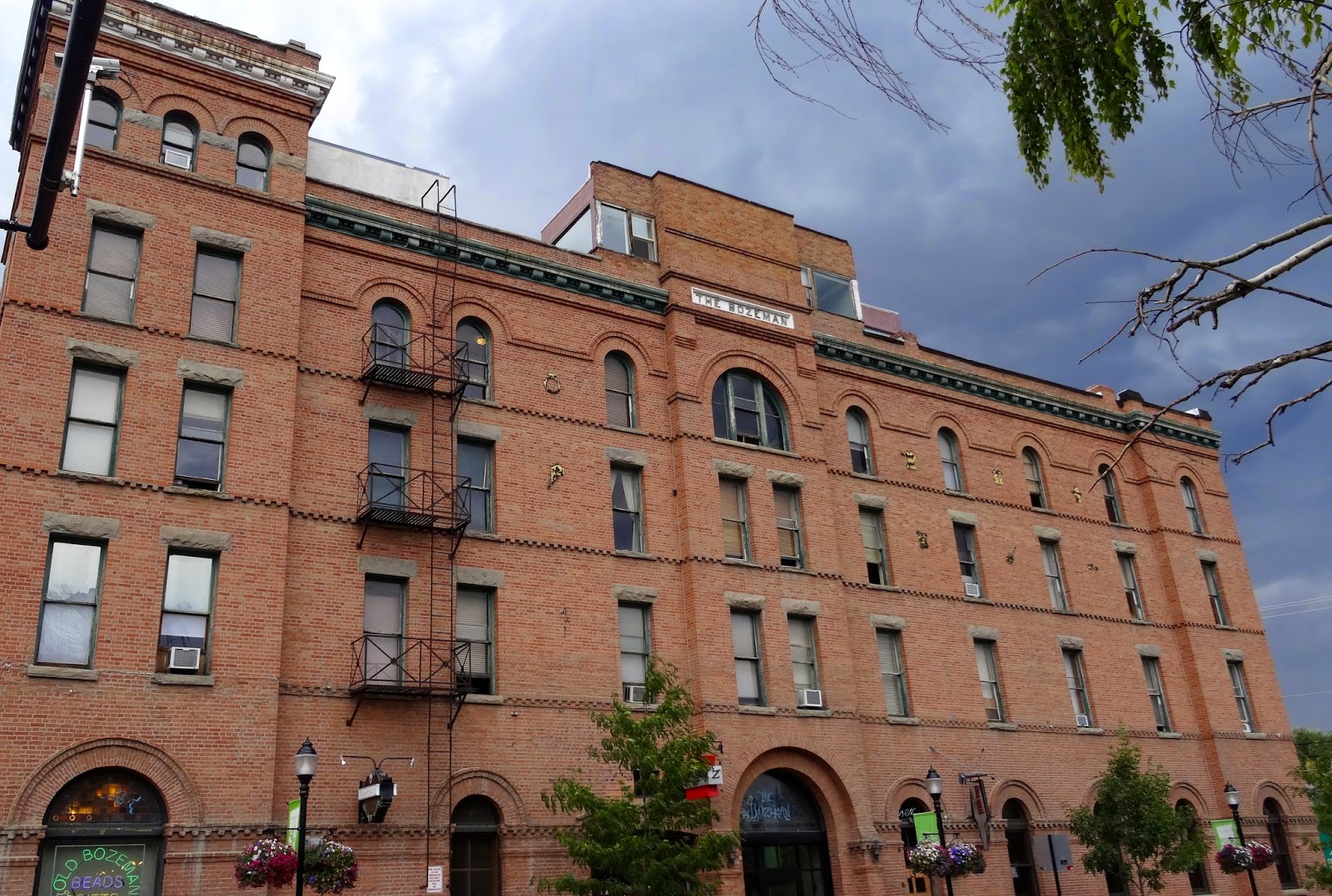
This is the Bozeman Hotel and Annex, in Bozeman, MT.  It was built in 1890 as part of the city's unsuccessful bid to become the state capitol and named for John Bozeman, who led people on nearby prospecting trips and help found the city. When John Bozeman was just 30 years old, he was murdered while traveling on the Yellowstone River.
Bozeman is home to many lovely sculptures like the one above.  There was a similarly inspired one of a bear at the Sunrise RV park where we stayed.
Cooper on an attempted getaway to a stream on Bozeman's Leverich Canyon Trail. We wanted to hike a highly rated trail on Sourdough Canyon, but it was closed for some repair work.  This trail was great but the road leading to it was narrow and bumpy.
While hiking in Leverich Canyon, Jim tested our bear spray.  They both work.
We had this type of view on our way to Missoula this morning. It later cleared up, then rained again this evening.  It's supposed to rain for the next few days.
A first for us was seeing plane fuselages being hauled via train alongside I-90. They are apparently going to a Boeing facility in Renton, Washington from a plant in Wichita, Kansas. In early July, a train carrying several of the fuselages derailed and three of the green machines slid down an embankment and into the Clark Fork River.  There is an interesting story about the derailment and a great photo you can see if you click  here. In 1966, Jim worked on the construction crew in Renton that built the hangars where various airlines paint their planes.

Jim relaxing after the Target medication fiasco.  He had a Flathead Lake Imperial IPA.  Bev had a Bufflehead Brown Ale.